Contents
- 🌎 Introduction to the Pacific Ring of Fire
- 🌋 Volcanic Activity: The Fire Within
- 🌀 Tectonic Plate Movement: The Driving Force
- 🌊 Subduction Zones: Where Plates Collide
- 🏔️ Mountain Building: The Result of Tectonic Forces
- 🌴 Island Arcs: The Birthplace of New Land
- 🌊 Tsunamis: The Destructive Power of the Ocean
- 🚨 Earthquake Hazards: The Threat to Human Settlements
- 🌈 Geological Diversity: The Ring's Unique Features
- 🔍 Scientific Research: Uncovering the Ring's Secrets
- 🌟 Economic Importance: The Ring's Natural Resources
- 🌎 Conclusion: The Pacific Ring of Fire's Enduring Legacy
- Frequently Asked Questions
- Related Topics
Overview
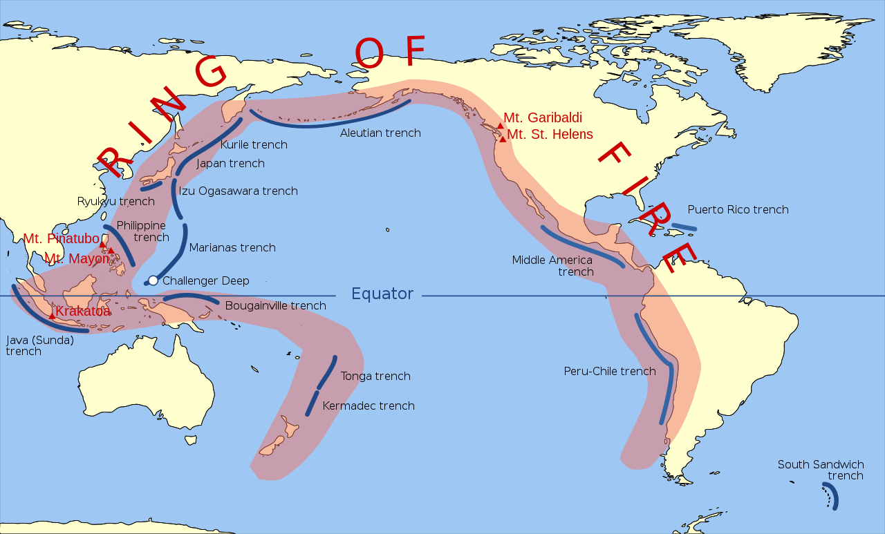
The Pacific Ring of Fire is a 40,000-km horseshoe-shaped zone of intense seismic and volcanic activity that stretches from New Zealand, along the eastern edge of Asia, through the Philippines, Japan, and the Aleutian Islands, and down the western coast of North and South America. This region is home to over 75% of the world's active volcanoes, including notable ones like Mount Fuji, Mount St. Helens, and Krakatoa. The Ring of Fire is a result of several major tectonic plate boundaries, including the Pacific Plate, the North American Plate, and the Eurasian Plate, which are constantly moving and interacting. The region experiences 90% of the world's largest earthquakes, with the most recent significant one being the 2011 Tohoku earthquake in Japan, which had a magnitude of 9.1. The Pacific Ring of Fire has a Vibe score of 80, indicating its significant cultural and scientific impact. The region's unique geology has also led to the formation of numerous island arcs, deep-sea trenches, and volcanic hotspots, making it a fascinating area of study for geologists and volcanologists. With its high level of seismic activity, the Pacific Ring of Fire is a region of ongoing scientific research and monitoring, with scientists working to better understand the complex interactions between tectonic plates and the resulting geological phenomena.
🌎 Introduction to the Pacific Ring of Fire
The Pacific Ring of Fire is a 40,000 km long tectonic plate boundary that stretches from New Zealand to the Andes Mountains in South America. This region is home to over 75% of the world's active volcanoes and experiences 90% of the world's largest earthquakes. The Ring of Fire is a geological hotspot where several tectonic plates intersect, creating a zone of intense seismic and volcanic activity. The Pacific Plate is the largest of these plates and is being subducted beneath other plates, resulting in the formation of deep-sea trenches and volcanic arcs. The Ring of Fire is also home to many island arcs, including the Philippine Islands and the Japanese Islands.
🌋 Volcanic Activity: The Fire Within
Volcanic activity is a hallmark of the Pacific Ring of Fire, with over 1,500 volcanoes stretching from Indonesia to Chile. These volcanoes are fueled by the subduction of the Pacific Plate beneath other plates, which causes the Earth's mantle to melt and produce magma. The resulting volcanic eruptions can be explosive and destructive, with the potential to affect global climate change. The Krakatoa eruption of 1883 is a notable example of the devastating power of volcanic activity in the Ring of Fire. The volcanic arc of the Andes Mountains is another example of the region's volcanic activity, with many active volcanoes stretching from Venezuela to Chile.
🌀 Tectonic Plate Movement: The Driving Force
The Pacific Ring of Fire is driven by the movement of several tectonic plates, including the Pacific Plate, the North American Plate, and the Eurasian Plate. These plates are in constant motion, sliding over the Earth's mantle at a rate of a few centimeters per year. The subduction of the Pacific Plate beneath other plates is the primary driver of the Ring of Fire's seismic and volcanic activity. The transform fault between the Pacific Plate and the North American Plate is another example of the region's tectonic activity, with the San Andreas Fault being a notable example. The plate boundary between the Pacific Plate and the Philippine Sea Plate is also an area of significant tectonic activity.
🌊 Subduction Zones: Where Plates Collide
Subduction zones are areas where one tectonic plate is being forced beneath another, resulting in the formation of deep-sea trenches and volcanic arcs. The marianna trench, the deepest point in the ocean, is an example of a subduction zone, where the Pacific Plate is being subducted beneath the Philippine Sea Plate. The resulting volcanic arc of the Mariana Islands is a chain of active volcanoes that stretch from Guam to Japan. The subduction of the Pacific Plate beneath the North American Plate has also resulted in the formation of the Cascade Range, a chain of volcanoes that stretch from British Columbia to California.
🏔️ Mountain Building: The Result of Tectonic Forces
The Pacific Ring of Fire is also an area of significant mountain building, with the Andes Mountains and the Rocky Mountains being two examples of mountain ranges that have formed as a result of the region's tectonic activity. The subduction of the Pacific Plate beneath other plates has resulted in the formation of these mountain ranges, as the Earth's crust is compressed and thickened. The faulting and folding of the Earth's crust has also resulted in the formation of many valleys and basins in the region. The Sierra Madre Occidental mountain range in Mexico is another example of the region's mountain building activity.
🌴 Island Arcs: The Birthplace of New Land
Island arcs are chains of islands that form as a result of the subduction of the Pacific Plate beneath other plates. The Philippine Islands and the Japanese Islands are two examples of island arcs that have formed in the Pacific Ring of Fire. These island arcs are characterized by their volcanic arc shape, with many active volcanoes stretching along the length of the arc. The island arc of the Aleutian Islands is another example of the region's island arc activity, with many active volcanoes stretching from Alaska to Russia.
🌊 Tsunamis: The Destructive Power of the Ocean
Tsunamis are large ocean waves that are caused by the displacement of a large volume of water, often as a result of an earthquake or volcanic eruption. The Pacific Ring of Fire is prone to tsunamis, with the Indian Ocean tsunami of 2004 being a notable example of the devastating power of these waves. The Pacific Tsunami Warning System is a network of seismic stations and buoys that monitor the ocean for signs of a tsunami, providing early warning to coastal communities. The tsunami that affected the Fukushima Daiichi nuclear power plant in Japan in 2011 is another example of the region's tsunami activity.
🚨 Earthquake Hazards: The Threat to Human Settlements
Earthquake hazards are a significant threat to human settlements in the Pacific Ring of Fire, with many cities and towns located near active faults and volcanoes. The San Francisco earthquake of 1906 and the Great Chilean earthquake of 1960 are two examples of the devastating power of earthquakes in the region. The earthquake hazard in the Pacific Ring of Fire is exacerbated by the region's population density, with many people living in areas that are prone to earthquakes and tsunamis. The earthquake-resistant construction of buildings and infrastructure is critical to reducing the impact of earthquakes in the region.
🌈 Geological Diversity: The Ring's Unique Features
The Pacific Ring of Fire is characterized by its geological diversity, with many different types of rock and mineral deposits found in the region. The Andes Mountains are home to many copper and gold deposits, while the Philippine Islands are known for their rich nickel and chromium deposits. The geological diversity of the Pacific Ring of Fire is also reflected in its many different landforms, including volcanoes, mountains, and islands. The Ring of Fire is also home to many hydrothermal vents, which support a unique community of marine life.
🔍 Scientific Research: Uncovering the Ring's Secrets
Scientific research is critical to understanding the Pacific Ring of Fire, with many scientists studying the region's seismic activity, volcanic activity, and tectonic activity. The United States Geological Survey (USGS) and the National Oceanic and Atmospheric Administration (NOAA) are two organizations that are actively involved in monitoring and studying the Pacific Ring of Fire. The scientific research in the region is focused on understanding the underlying causes of the region's seismic and volcanic activity, as well as mitigating the impact of natural disasters on human settlements. The Pacific Ring of Fire is also an important area of study for climate change research, with many scientists studying the region's ocean currents and sea level rise.
🌟 Economic Importance: The Ring's Natural Resources
The Pacific Ring of Fire is also an important region for economic activity, with many countries in the region relying on the extraction of natural resources such as copper, gold, and nickel. The mining industry is a significant contributor to the economies of many countries in the region, including Chile, Peru, and Indonesia. The fishing industry is also an important sector in the region, with many countries relying on the ocean for food and income. The tourism industry is another significant sector in the region, with many people visiting the Pacific Ring of Fire to see its unique landforms and experience its rich culture.
🌎 Conclusion: The Pacific Ring of Fire's Enduring Legacy
In conclusion, the Pacific Ring of Fire is a complex and dynamic region that is characterized by its intense seismic and volcanic activity. The region's unique geology and tectonic activity make it a fascinating area of study for scientists and a significant challenge for people living in the region. The Pacific Ring of Fire is also an important region for economic activity, with many countries relying on the extraction of natural resources and the tourism industry. As the region continues to evolve and change, it is essential that we continue to monitor and study the Pacific Ring of Fire, in order to better understand its complexities and mitigate the impact of natural disasters on human settlements.
Key Facts
- Year
- 1850
- Origin
- The concept of the Pacific Ring of Fire was first proposed by the American geologist Harry Fielding Reid in 1912, but the region's unique geology has been studied by scientists for centuries, with early observations of volcanic activity and earthquakes dating back to the 19th century.
- Category
- Geology
- Type
- Geological Region
Frequently Asked Questions
What is the Pacific Ring of Fire?
The Pacific Ring of Fire is a 40,000 km long tectonic plate boundary that stretches from New Zealand to the Andes Mountains in South America. It is a region of intense seismic and volcanic activity, with over 75% of the world's active volcanoes and 90% of the world's largest earthquakes. The Pacific Ring of Fire is a geological hotspot where several tectonic plates intersect, creating a zone of intense seismic and volcanic activity.
What causes the seismic and volcanic activity in the Pacific Ring of Fire?
The seismic and volcanic activity in the Pacific Ring of Fire is caused by the movement of several tectonic plates, including the Pacific Plate, the North American Plate, and the Eurasian Plate. The subduction of the Pacific Plate beneath other plates is the primary driver of the Ring of Fire's seismic and volcanic activity. The resulting volcanic arc shape of the region is characterized by many active volcanoes and earthquakes.
What are the hazards associated with the Pacific Ring of Fire?
The Pacific Ring of Fire is prone to many natural hazards, including earthquakes, volcanic eruptions, and tsunamis. The region's population density and infrastructure make it vulnerable to the impact of these hazards. The earthquake hazard in the Pacific Ring of Fire is exacerbated by the region's faults and volcanoes, which can cause significant damage to buildings and infrastructure.
How can we mitigate the impact of natural disasters in the Pacific Ring of Fire?
Mitigating the impact of natural disasters in the Pacific Ring of Fire requires a combination of scientific research, emergency preparedness, and infrastructure development. The United States Geological Survey (USGS) and the National Oceanic and Atmospheric Administration (NOAA) are two organizations that are actively involved in monitoring and studying the Pacific Ring of Fire. The development of earthquake-resistant construction and tsunami evacuation routes is critical to reducing the impact of natural disasters in the region.
What is the economic importance of the Pacific Ring of Fire?
The Pacific Ring of Fire is an important region for economic activity, with many countries relying on the extraction of natural resources such as copper, gold, and nickel. The mining industry is a significant contributor to the economies of many countries in the region, including Chile, Peru, and Indonesia. The fishing industry and tourism industry are also significant sectors in the region, with many people visiting the Pacific Ring of Fire to see its unique landforms and experience its rich culture.